


M6 Junction 7: Great Barr Interchange – A34 Great Barr
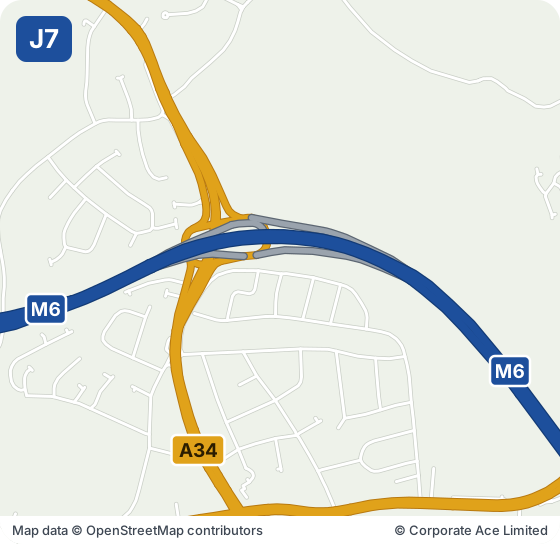
M6 Junction 7 at Great Barr meets the A34 between Birmingham and Walsall. Great Barr is right beside the junction, Walsall is about three miles to the north-west and West Bromwich and Wednesbury are a similar distance to the west. Sandwell Valley Country Park, with its lakes and walks, is under a mile and a half to the south-west, and Bishop Asbury Cottage, a small museum, is about a mile away. The Alexander Stadium is two miles to the south-east and Sutton Park is a little under four miles to the east.
| Junction | M6 J7 · Great Barr Interchange |
|---|---|
| Signed for | A34 · Great Barr / Birmingham |
| Nearest town | Walsall, 3.1 miles north-west |
| Roads at the junction | M5, A34, A4041, B4124, B4154, B4167 |
| Villages beside it | Great Barr |
| Next junction north | J8 (Ray Hall interchange), about 0.4 miles |
| Next junction south | J6 (Spaghetti Junction, Birmingham), about 3.6 miles |
| Along the M6 | 30 miles from J1 and 181 miles from J45 |
| Map section | Section 2: J4A–J10A, Birmingham and the Black Country |
Live Traffic at M6 Junction 7
The speed strip below shows the M6 from Junction 5 to Junction 9, both directions, from National Highways’ live data, checked every five minutes.
Live traffic speed flow: M6 Junctions 5 to 9
Untick all three to see just the speeds. We show the important overhead signs and the mandatory speed limits (red ring); see every overhead sign.
Go to our live M6 traffic speed flow map ›
NOTE: The speed flow, overhead sign messages or other information shown on our live traffic speed flow map is updated every few minutes. We cross check the data and aim to provide warnings if there could be a delay or an inaccurate speed reading. There can be occasions, beyond our control, and despite our best efforts where the speed flow could be inaccurate. We cannot therefore guarantee the speed you can expect on any stretch of the motorway is always accurately shown. However we hope you will find our live traffic speed flow map a useful tool in trying to plan your journey. Safe driving.
Refresh the page to see the latest speeds.
How Busy Is the M6 at Junction 7?
The Department for Transport counts traffic on the stretches either side of this junction; its latest figures are in the table. See how busy the M6 is junction by junction.
| Stretch (DfT label) | All vehicles a day | Lorries | Miles |
|---|---|---|---|
| J8E to J7 | 174,714 | 24,159 (13.8%) | 0.5 |
© M6Traffic.co.uk · Statistics from the Department for Transport, 2025
Around M6 Junction 7: Towns and Places on the Map
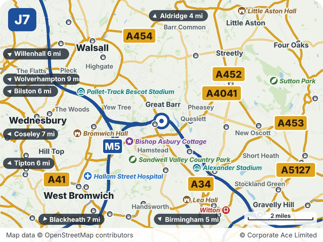
| Place | What it is | From the junction |
|---|---|---|
| Bishop Asbury Cottage | Attraction | About 1 mile south-west |
| Sandwell Valley Country Park | Park or nature reserve | About 1.5 miles south-west |
| Alexander Stadium | Venue | About 2 miles south-east |
| Lea Hall | Historic house or castle | About 2.5 miles south |
| Bromwich Hall | Historic house or castle | About 2.5 miles west |
| Pallet-Track Bescot Stadium | Venue | About 2.5 miles west |
| Hallam Street Hospital | Hospital | About 3 miles south-west |
| Witton | Railway station | About 3.5 miles south-east |
| Sutton Park | Park or nature reserve | About 3.5 miles east |
| Little Aston Hall | Historic house or castle | About 4 miles north-east |
Junctions Either Side
- J6Gravelly Hill InterchangeA38(M) · Spaghetti Junction, BirminghamNearest town: Birmingham, 2.7 miles
- J8Ray Hall InterchangeM5 · Ray Hall interchange (M5 to the South West)Nearest town: Walsall, 2.1 miles
Live traffic news at M6 Junction 7
Incidents and roadworks between Junction 6 and Junction 8 that we are aware of.
M6 - M42 link road hardshoulder closure northbound
13:06 (1:06pm)22 Nov 2026reported 5 min ago
- Location
- link road from M6 J4A southbound to M42 J8 northbound
- Direction
- Northbound
- Lanes closed
- Hard shoulder closed
- Reason
- Road improvement or upgrading
- Schedule
- 05:00 (5am) Mon 2 Nov 2026 → 05:00 (5am) Mon 7 Dec 2026
+ 2 more near Junction 7 - see all the M6 traffic news →
This is the news for Junction 7 only, not the whole M6. For the rest of the motorway see all the latest M6 traffic news, the overhead signs and the speed limits in force now.
Updated 13:12 (1:12pm) Sun 22 Nov 2026